| Home
Copyright 2004
|
| Home
Copyright 2004
|
|
A mighty eygre reared his crest" 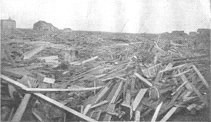
The Galveston, Texas 1900 Storm IMPORTANT: The information and photographs
found in this file have been extracted from The Great Galveston Disaster,
by Paul Lester. This material now resides in the Public Domain.
Interested readers may download this file for personal, non-commercial
use only.
TABLE OF CONTENTS . Introduction . The Storm Path . The Approach . The Storm . Aftermath . Mortality . Property Destruction . Looting and Crime . Cleanup . Individual Stories . List of Known Victims
Home
INTRODUCTION On September 8, 1900, the island community of Galveston, Texas was hit by a ferocious storm that killed thousands of residents, and nearly flattened the city. The story of the great storm will never be fully told. Words are too weak to express the horror, the awfulness of the storm itself, to even faintly picture the scene of devastation, wreck and ruin, misery, suffering and grief. Even those were were miraculously saved after terrible experiences, were spared to learn that their families and property had been swept away, and spared to witness scenes as horrible as the eye of man ever looked upon - even these cannot tell the story. There are stories of wonderful rescues and escapes, each of which at another time would be a marvel to the rest of the world, but in a time like this when a storm so intense in his fury, so prolonged in its work of destruction, so wide in his scope, and so infinitely terrible in its consequences has swept and entire city and neighboring towns for miles on either side, the mind cannot comprehend all of the horror, cannot learn or know all of the dreadful particulars. One stands speechless and powerless to relate even that which he has felt and knows. Gifted writers have told of storms at sea, wrecking of vessels where hundreds were at stake and last. That task pales to insignificance when compared with the task of telling of a storm which threatened the lives of perhaps sixty thousand people, sent to their death perhaps six thousand people, and left thousands others wounded, homeless, and destitute, and still others to cope with grave responsibility, to relieve the stricken, to grapple with and prevent the anarchist's reign, to clear the water-sodden land of putrefying bodies and dead carcasses, to perform tasks that try men's souls and sicken their hearts. The tidal wave along the Texas coast, brought on by the storm, will rank among the most disastrous events in history.
THE STORM PATH Dr. H. C. Frankenfeld, forecast official of the Weather Bureau, gave an account of the West India hurricane that traveled through Texas. The first sign of the storm was noticed August 30, 1900, hear the Windward Islands, about latitude 15 degrees north, longitude 63 degrees west. On the morning of August 31 it was still in the same latitude, but had moved westward to about longitude 67 degrees, or about 200 miles south of the island of Porto Rico [sic]. At that time, however, it had not assumed a very definite storm formation. The storm was central in the Caribbean Sea on the morning of September 1st, evidentially about 200 miles south of Santo Domingo City. By September 2nd, it has reached a point somewhere to the southwest, and not very far form Jamaica. The morning of September 3rd found it about 175 miles south of the middle of Cuba. It had moved northwestward to latitude 21 degrees and longitude 81 degrees by September 4th. Up to this time the storm had not developed any descriptive force but had caused heavy rains, particularly at Santiago, Cuba, where 12.58 inches of rain fell in 24 hours. On the morning of the fifth, the storm centre had passed over Cuba and had become central between Havana and Key West. High winds occurred over Cuba during the night of the 4th. By the morning of the sixth, the storm centre was a short distance northwest of Key West, FL, and the high winds had commenced over Southern Florida, forty-eight miles from the N. E. from Key West. At this time it became a question as to whether the storm would recurve and pass up along the Atlantic coast, a most natural presumption judging from the barometric conditions over the eastern portion of the US, or whether it would continue northwesterly over the Gulf of Mexico. Advisory messages were sent as early as September 1st to Key west and the Bahama Islands, giving warning of the approach of the storm. The warning were supplemented by others on the second, third and fourth, giving more detailed information, and were gradually extended along the gulf coast as far as Galveston and the Atlantic coast to Norfolk. On the morning o of the 7th, the storm was apparently central south of the LA coast. At this time storm signals were ordered up n the North Texas coast, and during the day were extended along the entire coast. On the morning of the eighth the storm was nearing the TX coast, and was apparently central at about latitude 28, longitude 94. The last report received from Galveston, dated 3:40 PM, September 8, showed a barometric pressure of 29.22 inches, with a wind of 42 MPH, northeast, indicating that the center of the storm was close to the city. At this time the heavy sea from the southeast was constantly rising and already covered the streets of about half the city. Up to Sunday morning, after the storm had passed Galveston, no reports were received from southern TX, but the barometer at Fort Worth gave some indications that the storm was passing into the southern portion of the state. An observation taken at San Antonio at 11 o'clock, but not received until half-past five, indicated that the centre of the storm had then turned in the northward. Later, Dr. J. T. FRY, who had been an observer of the weather for years, had a theory that the storm which visited Galveston Island originated in the vicinity of Port Eads, and was not the hurricane which was reported on the Florida coast. On Thursday a storm was reported moving in a northeasterly direction from Key West. It moved up the Atlantic coast. The Mallory steamer "Comal" ran into it and reported a great number of wrecks as was reported in the "News" at the time. The supposition that this was the same storm that reached Galveston by doubling back on its tracks is a mistake.
|
|
Copyright Notice: All files on this site are copyrighted by their creator and/or contributor. They may be linked to but may not be reproduced on another site without specific permission from Ellen Pack <e.j.pack@natchezbelle.org> and/or their contributor. Although public information is not in and of itself copyrightable, the format in which they are presented, the notes and comments, etc., are. It is however, quite permissable to print or save the files to a personal computer for personal use ONLY. not-for-profit site brought to you as a public service by
Copyright 2000-2004 Ellen Pack - All Rights Reserved |