Primative camp shelters are located along the trail at different intervals. Most shelters have a cistern water supply or a spring or nearby well. All water should be treated.
Topographical maps and a trail guide are required for each section of the Jenny Wiley Trail. These maps can be purchased from:Kentucky Department of Commerce
Map Sales
133 Holes Street
Frankfort, KY 40601
502-564-4715
.
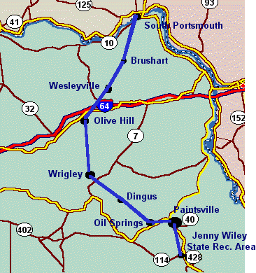
SECTION DEPART DESTINATION DISTANCE 1 South Portsmouth Horse Gap
Route 784;
Jct. 717.9 Miles 2 Horse Gap Davis Fork of McGlone Creek
Route 184, Jct. 219.2 Miles 3 Davis Gap Soldier
Route 17423.9 Miles 4 Soldier Blairs Mill
Route 71123.5 Miles 5 Blairs Mill Crockett
Route 17220.8 Miles 6 Crockett Falcon
Route 4024.5 Miles 7 Falcon Ivyton 13.9 Miles 8 Ivyton Jenny Wiley State Park 20.6 Miles
Most of the information on this page was gleened from public material produced by Kentucky State Parks, 500 Metro Street, 11th Floor, Capital Plaza Tower, Frankfort, KY 40601.
502- 564-2172
Return to The
Jenny Wiley Trail
.
Return to The Story
of Jenny Wiley
.
Return
to The Wiley Cabin of Walkers Creek
.
Return to Surname Files
Home
.
Ellen
Pack
This Page is Copyright
1998 - All Rights Reserved
.
1.Return to ChartOverlook of the Ohio River Lozier Trail - Privately owned Poet Lee Pennington's cabin Old Cemetery Return to ChartPortion of trail straddles Greenup and Lewis Counties. William's Shelter located in picturesque pastoral setting Portions of trail travels through old clay mine
Return to ChartJunction of Jenny Wiley and Simon Kenton Trail Portion of trail runs along ridge through bountiful ruffed grouse country
Return to ChartThis area contains a wide variety of wild flowers, ferns, and trees. Seasonal waterfalls Avoid this section during and soon after heavy rains Only section of the trail that is within the Daniel Boone National Forest Very scenic area
Return to ChartBeautiful scenery, but rough country. Caution advised due to possible bears, and eels in Devi's Fork Creek.
Return to ChartContains remote and primative areas Portions of trail follow old Indian trace Return to ChartShelter contains two bunks. Very scenic ridge with rock formations that allow panoramic views into the valleys below. Peak trail elevation - 1,425 ft. at Eagle Rock Overlook
Return to ChartVarious sectons of trail follows ridge. Interesting rock formations Jenny Wiley is believed to have followed Bear Hollow Creek to the Levisa Fork of the Big Sandy where she crossed the river to the safety of Harmon's Station. Beautiful section of trail, but rugged as it climbs and drops. Several scenic overlooks. Trail passes through a government cemetery. Tecumseh Overlook provides grand views of Dewey Lake.